Tourist Attractions
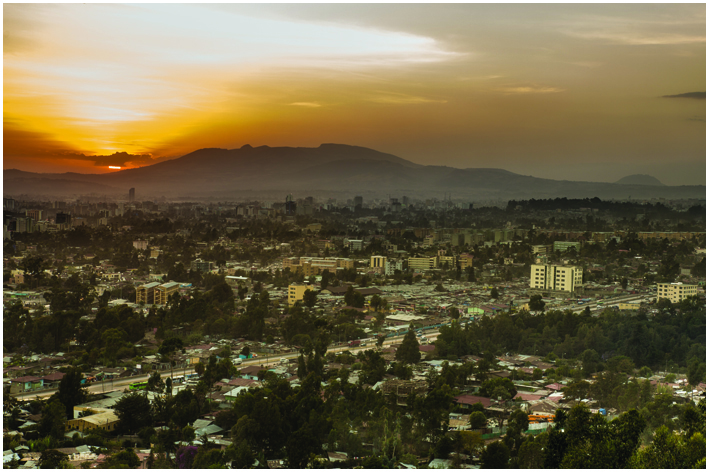
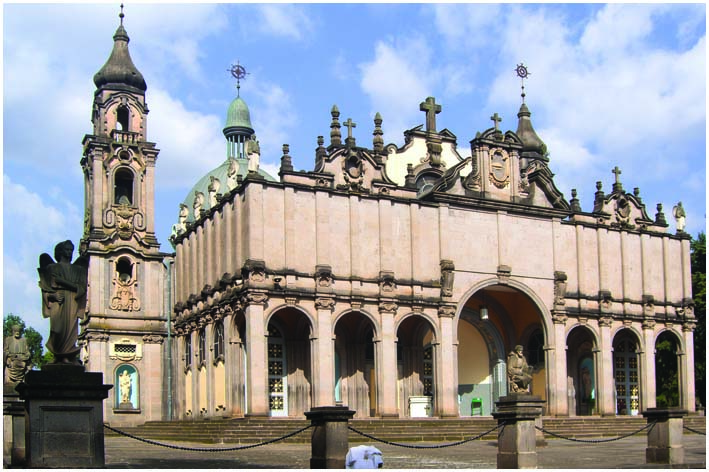
Addis Ababa – the New Flower
Wide tree-lined streets, fine architecture, glorious weather, and the incongruity of donkey trains trolling along the boulevards make Addis Ababa, the capital of Ethiopia, a delightful place to explore. It is a city of surprises characterized by remarkable diversity and contrasts. The world’s third highest capital city lies in the central highlands of Ethiopia at an altitude of 2,400m on the foot of mount Entoto. The city with its population of 3-4 million people, its dense traffic and numerous construction sites can be rather overwhelming on first exposure. However, Addis Ababa has a lot to offer and can keep you busy for several days. There are quite a few museums with great archeological discoveries like the Ethiopian National Museum, which preserves “Lucy” the fossil of hominid that lived some 3.5 million years ago, the Ethnological Museum which provides a great overview of all tribes living in the country, and last but not least the Red Terror Museum which deals with the period of the Derg Regime.
The best thing to do in Addis Ababa however is to walk around the different neighborhoods, dive into the hustle and bustle of the capital, take a break in one of the countless cafés with a delicious macchiato and just breath in the energy of the locals.
Addis Ababa is also known as capital of Africa due to the established headquarters of a number of international organizations such as the African Union (AU) and the United Nation Economic Commission for Africa (UNECA).
Axum
Axum is Ethiopia’s most ancient city. It does seem certain that a high civilization was established here by immigrants from southern Arabia in the centuries before the Christian era. By the first century AD – the time of the earliest historical records – Axum was well known to Greek traders as a fine city and also as the center of a considerable empire. Rising to importance about the time of the birth of Christ, Axum was the capital of the far-reaching Axumite kingdom, which dominated the vital crossroads of Africa and Asia for almost a thousand years. Its principal ecclesiastical building, the Church of St Mary of Zion, is where, according to Ethiopian legends, the Ark of Covenant resides, within a special sanctuary chapel. The Axumites introduced a universal written language, Ge’ez, and created a new imperial power and political cohesion in this part of Africa. They also gave Ethiopia its first organized religion – Christianity – in the fourth century AD. The spectacular rise of Islam in the seventh century was the main cause of the decline of Axum. Although there was no direct aggression, Arab influence in the Red Sea cut off trade and cultural relations and Ethiopia found itself isolated from the rest of the world. Axum’s dramatic end was caused by the rebellion against the Axumite kingdom and Christianity led by Queen Yodit who destroyed much of the ancient city, overthrew its last king, and killed the royal princess – thus interrupting the Solomonic line. In folklore, Queen Yodit is remembered as a monster and a destroyer of churches. However, after the decline of the Axumite realm the city remained Ethiopia’s religious capital as well as the place where several medieval emperors made their way to celebrate their coronation rites. The town abounds in archaeological remains, including the graves of kings, the foundations of a palace, inscribed tablets, and great carved obelisks.
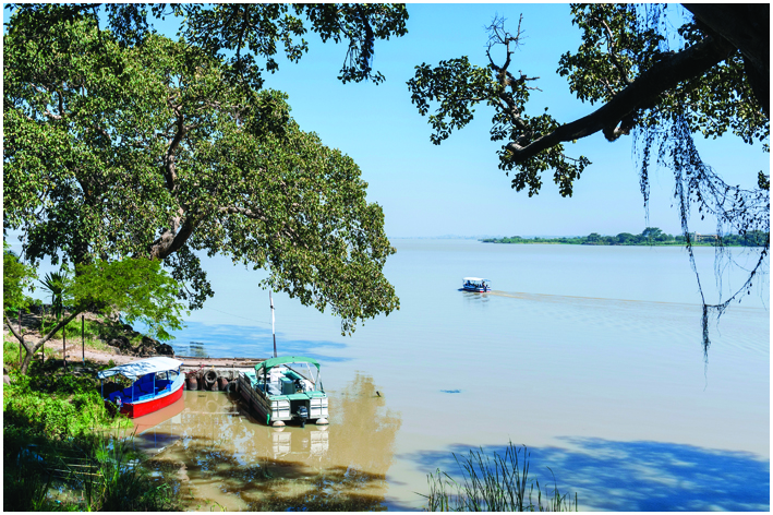
Bahir Dar
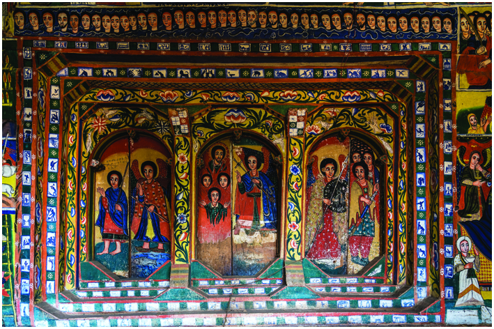
Bahir Dar, situated on the southern shore of Lake Tana, provides access to both the lake with its many islands and the Blue Nile Falls. The visitor will without a doubt see tankwas (papyrus canoes) on the lake shore and may at times also catch a glimpse of their construction. The town today with its wide, palm-lined avenues and gardens overflowing with tropical vegetation, is quite an attractive site where tourists love to settle in for a few days. Take it easy in Bahir Dar and relax on a boat while exploring the numerous monasteries on the islands and peninsulas of Lake Tana. This lake is Ethiopia’s largest, covering an area of over 3,500 km2, and its waters are the source of the Blue Nile, that flows through Ethiopia and Sudan until it unites with the White Nile. Its length is about 1600km. A full day can easily be filled by visiting most of the 20 monastic churches that were founded during the 14th century. The highlights however can also be seen in half a day. An outstanding church and a must-visit is the relatively easy accessible Ura Kidane Mihret church on the Zegwe Peninsula which is covered from top to bottom with paintings that collectively serve as a visual encyclopedia of Ethiopian ecclesiastical concerns. Countless colorful frescoes depict scenes from biblical lore and from the history of the Ethiopian Orthodox Church. Kebran Gabriel, the nearest monastery to Bahir Dar, is a principal tourist attraction for male visitors only, as this is one of the places where women are forbidden. It dates back to the 17th century and features a 12-columned portico and good paintings on the inner sanctuary. Another monastery, Dega Estefanos, is also closed for women unfortunately. A steep track up a winding path leads towards the monastery on the summit. Some 90m above the surface of the lake are the low, round, thatched-roof buildings that house the monks, and nearby an arch set into a high stone wall lead to a grassy clearing, at the center of which stands the church of Saint Stephanos. Although it was rebuilt in the 19th century, it houses a 16th century painting of the Holy Madonna, and mummified remains in glass coffins of five former Ethiopian emperors from the 13th to the 17th centuries. If you are interested in bird watching, you should not miss to visit Mitsele Fasiladas (Fasiladas Island) near the eastern side of the lake, which is the breeding base for a number of wetland species.
The Blue Nile Falls – also known as Tis Abay (Smoke of the Nile) or Tis Isat (Water that Smokes) – are located around 35 km away from Bahir Dar. The falls are up to 400 m wide when in flood, and dropping over a sheer chasm more than 35 m deep. They throw up a continuous spray of water which drenches onlookers up to a kilometer away. This misty deluge produces rainbows, shimmering across the gorge, and a small perennial rainforest of lush green vegetation. Although a hydroelectric project which has been built just upstream a few years back, took a bit of the majesty away, the Blue Nile Falls are impressive enough today.
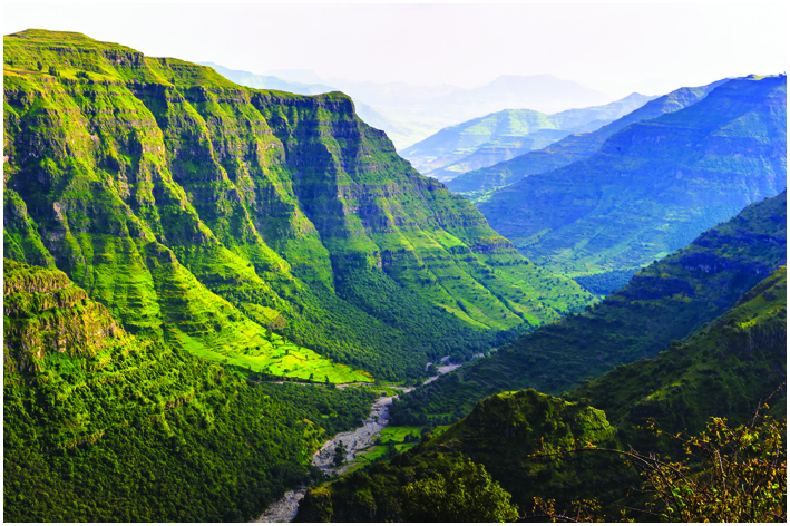
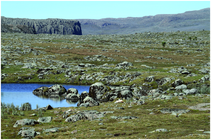
Bale Mountains National Park
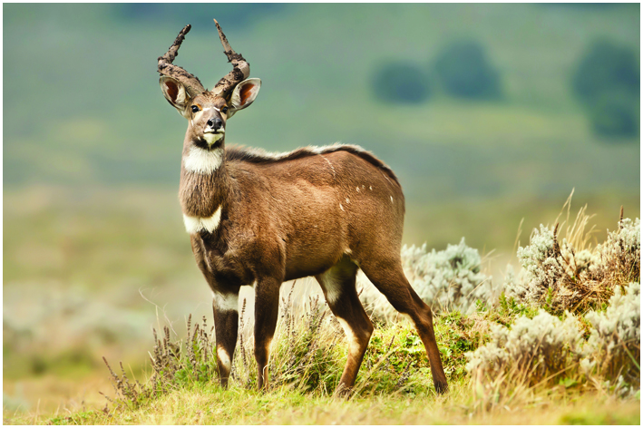
More than any other park in Ethiopia, Bale National Park is known for its wildlife. One can see the endemic Ethiopian Wolf and Mountain Nyala and over 60 mammal species and 260 bird species have been recorded. The 2,400 km2 large park is part is of relatively ancient volcanic origin, having formed from solid lava more than ten million years ago. It is home of Mount Tullo Deemtu (4,377m), the second highest peak in Ethiopia and is fascinating with beautiful landscapes and scenic views of river cut deep gorges, several waterfalls and heavily forested areas and highlands along century old paths. Here one can hike through wild-flower displays or wild alpine scenery like on the Sanetti plateau, the world’s largest expanse of Afro-alpine moorland. At the southern end of the plateau the Harena Escarpment offers an astonishing view over the Harena forest. The forest is far denser than the juniper woodland and home to the newly discovered Bale monkey. Further mammals include the olive baboon, Guerza monkey and bushbuck. Large animals such as lion, leopard and African wild dog are still resident around this area but seldom seen by visitors. Main attractions when visiting the Bale Mountains are also the stunning Sof Omar Caves in the East of the park. Once a refuge for the Muslim leader Sheikh Sof Omar during the 12th century the vast network of limestone caverns remain an important site of pilgrimage for Ethiopian Muslims. The approach to the caves is made through the tiny village of Sof Omar, settled on the cliffs above the Web River. The inside of the caves feature soaring pillars of stone twenty metres high, fluted archways and tall airy vaults until the river is reached, flowing through a deep gorge.
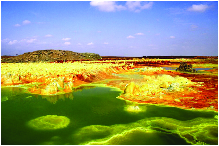
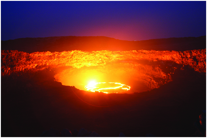
Danakil Depression
An excursion to the astounding area of Danakil isn’t something everyone can handle, however something nobody will ever forget. The Danakil Desert to the East of the Tigraian higlands is one of the world’s most geological hyperactive regions and renowned to be the hottest place on earth reaching daytime temperature soaring 50°C. Ert’Ale, (613m) the famous volcano has been in the state of continuous eruption since 1967 and its small southerly crater is the only permanent lava lake on the planet. The North of Ert’Ale, near Lake Asale is home of the lowest place of the continent, Dallol lays 116m below sea level. Because of its low elevation the depression has been repeatedly flooded by the Red Sea, most recently about 30,000 years ago. With each incursion the seawater evaporated, leaving behind thick layers of salt, which still form a major item of trade for the Afar people. Collected at the salty shores of Lake Afar, 30 km in the south of Ert’Ale the salt-bars are transported on camelback all the way to Tigray along the ancient caravan routes with more than thousands of camels lined up.
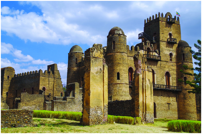
Gondar
Located in the North of Lake Tana, on the foot of the Simien Mountains and surrounded by fertile land, Emperor Fasilades made Gondar his capital in 1636. That time the city has been the crossroads of three major caravans and grew as an agricultural market town, serving as major trade centre of Ethiopia. Today Gondar is referred to as “the Camelot of Africa” providing 17th century royal stone castles and palaces, which have been built by different Emperors reining the country. Even though the city has been looted by Sudanese Dervishes and bombed by the British during the liberation campaign in 1941, much of Gondar remained very well intact and famous buildings such as the Fasilades Castle, Iyasu’s Palace, Dawit’s Hall, Fasilades Bath, the Mentewab’s Castle and Debre Berhan Selassie one of Ethiopia’s most colourful and famous churches can be visited. During Emperor Yohannes I in 1668, Gondar has been divided into several neighbourhoods; Addis Alem, where the Muslim community dwelled, Kayla Meda, where the Beta Israle (Ethiopian Jewes) lived, Abun Bet and Qagn Bet, the home to nobility. The city is a good base to make the leap into the Simien Mountains.
Harar
The old walled city, locally known as Jugol, provides travellers a great contrast between the animist tribes of the South and the Christian highlands of the North. Harar, established in 1520, is considered to be the Islam’s fourth holiest city providing countless mosques. Six gates are the only gateway to the city that has been rewarded with the UNESCO ‘city for peace’ price due to its rich sense of community between its Muslim and Christian inhabitants. Additionally, its small alleyways, closely build white and blue two-stock houses (geygar) and colourful markets throughout the city offer a unique ambience. Symbols of the city and great sites to visit are also the Palace of Menelik II and the Jamii Mosque.
The city is renowned for its hyena men feeding the wild animals every evening according to a traditional festival dating back to a famine many centuries ago.
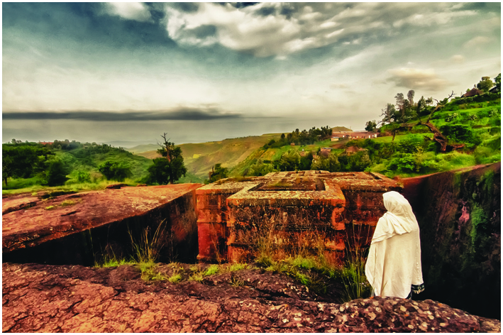
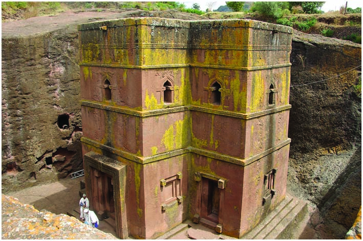
Lalibela
The small town of Lalibela in Northern Ethiopia is home to one of the world’s most astounding sacred sites: eleven rock-hewn churches, each carved entirely out of a single block of granite with its roof at ground level. Of Lalibela’s roughly 15,000 people, over 1,000 are priests. Religious ritual is central to the life of the town, with regular processions, extensive fasts, crowds of singing and dancing priests. This, combined with its extraordinary religious architecture and simplicity of life, gives the city of Lalibela a distinctively timeless, almost biblical atmosphere. Lalibela was originally known as Roha. It was renamed after the 12th-century King Lalibela, who commissioned these extraordinary churches. Lalibela was a member of the Zagwe dynasty, which had seized the Ethiopian throne around 1,000 AD. When his rivals began to increase in power, Lalibela sought the support of the powerful Ethiopian Orthodox Church by building the churches in this small town. King Lalibela’s goal was to create a New Jerusalem for those who could not make a pilgrimage to the Holy Land. The churches of Lalibela were not constructed — they were excavated. Each church was created by first carving out a wide trench on all four sides of the rock, then painstakingly chiseling out the interior. The largest church is 40 feet high, and the labor required to complete such a task with only hammers and chisels is astounding. Popular legend has it that angels came every night to pick up where the workmen had left off. One of the churches, Bet Maryam, contains a stone pillar on which King Lalibela wrote the secrets of the buildings’ construction. It is covered with old cloths and only the priests may look on it. The churches have been in continuous use since they were built in the 12th century. The first Europeans to see these extraordinary holy sites were Portugese explorers in the 1520s, one of whom noted in his journal that the sights were so fantastic he expected readers of his descriptions would accuse him of lying. The roofs of the Lalibela churches are level with the ground and are reached by stairs descending into narrow trenches. The churches are connected by tunnels and walkways and stretch across sheer drops. The interior pillars of the churches have been worn smooth by the hands of supplicating worshippers. The rock-cut churches are simply but beautifully carved with such features as fragile-looking windows, moldings of various shapes and sizes, different forms of crosses, swastikas (an Eastern religious motif) and even Islamic traceries. Several churches also have wall paintings. Each church has its own resident monk who appears in the doorway in colorful brocade robes. There are eleven rock-cut churches at Lalibela, the most spectacular of which is Bet Giorgis (St. George’s). Located on the western side of the cluster of churches, it is cut 40 feet down and its roof forms the shape of a Greek cross. It was built after Lalibela’s death (ca.1220) by his widow as a memorial to the saint-king. It is a magnificent culmination of Lalibela’s plans to build a New Jerusalem, with its perfect dimensions and geometrical precision.
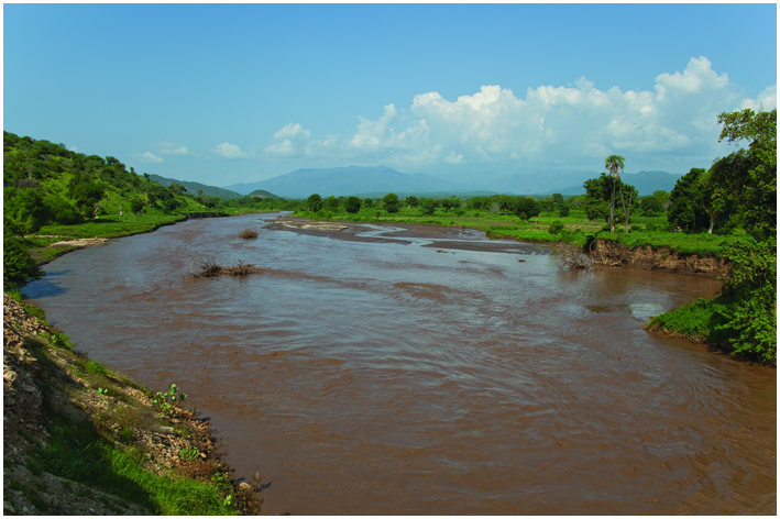
Rift Valley
With ancient stelae fields, numerous hot springs and five lakes, the 275km long valley is the gateway to southern Ethiopia’s riches. Lake Ziway surrounded by blue volcanic hills is the largest of the Rift Valley Lakes. Here it is possible to observe Hippos and different birds such as the white pelican, saddle bill, yellow bill, kingfishers and storks. Further in the South lies Lake Langano, which is the only one free of Bilharzia and safe to swim. The area provides several good hotels and lodges and some water sport facilities. Nearby, the Lakes Shala and Abyata provide a stunning spectacle of untouched, unspoilt Ethiopia. Lake Abyata hosts an extraordinary number of birds like wild duck, geese, cormorants, flamingos and great numbers of Great White Pelicans. These pelicans come only to Abyata to feed; they nest and sleep on islands in neighbouring Lake Shala, which is a crater lake having bays covered with wild fig, acacia and euphorbia, overlooking dark waters which are with 200m the deepest in Ethiopia. There is not much wild life around the lakes but the beautiful Grant’s gazelle, zebras and different species of monkeys can be seen regularly.
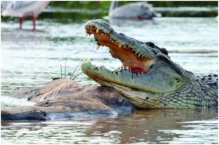
To the South of Arbaminch lies Lake Chamo, which is renowned for its crocodile market, where it is possible to observe hippos and the great Nile crocodile, the largest species of crocodiles.
South Omo Valley
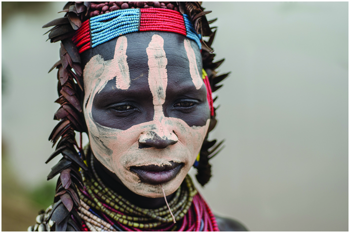
One of the places not to miss when visiting Ethiopia is the area of South Omo Valley and its rural communities. Descending from the green urban highlands into the lowlands of South Omo feels like a journey through space and time. For generations the tribes of Omo Valley have been isolated from the outside influence by mountains, savannah and the unique status of Ethiopia, being the only African country that has never been colonized by Europeans. Even though the region is changing, South Omo is still one of the continent’s most intact landscapes and as close as one can come to an Africa untouched by the outside world. Hints of Africa as it once was, appear in the large clay plates worn behind the lower lips of the Mursi women as symbol of beauty, or the Hamar ritual in which the women demand to be whipped until bleed and the cattle jumping in which boys prove they are ready for manhood. Other renowned tribes are the Suri, Karo and the Ari.


Get In Touch
![]() Kebene, Arada Sub-City,
Kebene, Arada Sub-City,
Negatu Bldg
![]() +251 911 948046
+251 911 948046
![]() 14615, Addis Ababa, Ethiopia
14615, Addis Ababa, Ethiopia
![]() info@rasrobeentours.com
info@rasrobeentours.com
rasrobeen@gmail.com